Little Prairie Conservation Area, Dissertation Example
Introduction
This chapter describes the topography information of study area, the geological features, and the soil composition. In addition, the significance and construction of Willam E. Towell Dam will be described. The following chapter will include the geology of the William E. Towell (Little Prairie) Lake, an aerial photo, and the description of a number of sinkholes that exists in Phelps County. The Willam E. Towell Lake is located in a conversation area, and is a popular destination for adventure tourists and nature lovers alike. However, it offers a variety of landscape: shoreline of the lake, fishing ponds, a named Prairie nearby (Heilbrunn Prairie), as well as imminent and permanent streams.
Topography of the study area
The Little Prairie Lake (man-made) is located in Dillon, Phelps County, Missouri at the latitude and longitude coordinates of 37.9950419 and -91.6901571 at an elevation of 1,032 ft. above mean sea level (Figure A). It is surrounded by forests, and on the South-East by a Prairie. The area of the Little Prairie Conservation Area also has old fields (Missouri Department of Conservation, n. d.). The lake has one concrete boat ramp on the North-East shore of the lake.
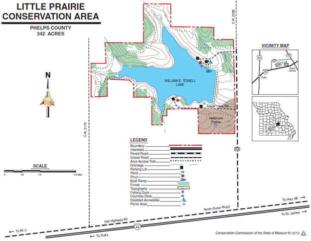
Figure A: Topographic map of study area (Missouri Conservation Department).
A topographical map of the Little Prairie Lake can be seen in figure A. The basic shape is a “V” opening to the North-Western direction, but the shores on the southern edge of the “V” are much more varied and jagged than those on the northern side of the V. The immediate surrounding area of the lake, regardless of terrain, is not remotely flat. The broader lake area is about 342 acres. There are two main streams entering the lake, and those are on the south-central and the northeastern edge, giving the lake two fingered configuration. Both streams meet approximately close to the dam (Figure A). The outflow is constructed as a concrete drop-inlet spillway, through the dam into intermittent (Missouri Conservation Department, n.d.).
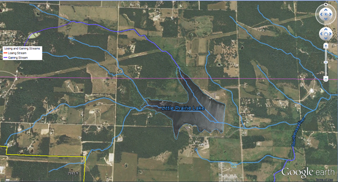
Figure B: Stream channels of Little Prairie Lake
The Heilbrunn Prairie lies South-East from the lake, and it is significant, as it is also a part of the Little Prairie Conversation area, which is protected by the Department of Conservation. While the area is man-made, it has a significant role in the geography of the surrounding cities’ population. The entire conservation area is owned by MDC, and recreational tourism is managed, as well as controlled in the area. The main land cover types of the lake’s surroundings, according to the Missouri Department of Conservation (n.d.) are listed below:
97.6 acres of forest and woodland
95.2 acres of lakes and ponds
95 acres of old fields
32 acres of Native Prairie
95 acres of other field
19.61 acres of service facilities, such as parking lots and roads.
William Towell Dam
The William Towell Dam is made up of earthen construction. The construction has been made by the Missouri Conservation Department. The core of the dam is earth, while the foundation is rock. It was completed in 1965, but was upgraded in 1988. It has a height of nearly forty-eight feet, and it stands nearly fifteen hundred feet long. The overall maximum discharge of the dam is about 3150 cubic feet per second, and its capacity is about 1320 acre feet. The normal storage of the dam is about 1300 acre feet, and the total drainage is about 1,540 acres. The dam itself in on a tributary of the Boubeuse River in Phelps County, Missouri. The dam and the associated areas, just like the lake and the nearby Prairie are used for recreational purposes. The overall usable surface area is about 100 acres, and the area is owned and operated by the Missouri Department of Conservation. The maximum depth of the lake is 34 feet.
The William Towell Dam is a regulated dam, according to the records of the Missouri Department of Natural Resources (n.d.). It is the one of the three regulated dams in Phelp County, out of 29. It has a hazard classification of 1, and the largest lake (100 acres) in the county with the largest drainage (1540 acres) area.
Bourbeuse River
The Bourbeuse flows to the northeast from nearby Dillon in Phleps County. It also travels through Maries County, Gasconade County, Crawford County and Franklin County. The word “boubeuse” is French for “muddy” and it is the name of the river that is located in east-central Missouri in the greater Ozarks area. It is one of the two major tributaries of the Meramec River, as it runs through Missouri. At the end of its trip, the river discharges into the Meramec River in the greater Moselle area. An aerial map of the above flow and movement can be seen in Figure B (Missouri Conservation Department).
Geology of the study area
The geologic setting of the study area is rather typical for this part of the Salem Plateau Uplands. The lake site and watershed are underlain by Ordovician age Jefferson City Dolomite.
Pennsylvanian deposits which cap the Jefferson City Dolomite consists of medium to massive beds of dolomite, which is relatively watertight. The overlying pattern is silt loam on the flood plain,and silt loam underlain by silty clay on the weathered slopes. (NRD)
Soil Composition of Lake
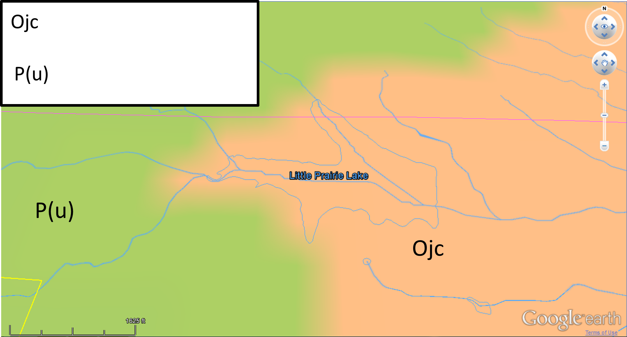
Figure C: Geological map of study area. (RND).
The majority of Phelps County is situated on the Salem Plateau. There are isolated knobs and hills, higher in elevation, that are remnants of the Springfield Plateau.
Bedrock in the county consists mostly of sedimentary cherty dolomite, sandstone, and clay that range from Ordovician to Pennsylvanian in age. A layer of loess and erosional deposits, generally 1 foot to 2 feet thick, covers bedrock or stony residual material. The bedrock has a gentle regional dip of 2 to 3 degrees to the north or northwest. The county has no known major fault systems, although smaller local faults do exist. These faults are old geologically and have no record of “recent” movement. The subsurface formation are composed of massive layers of dolomite, cherty dolomite, and sandstone and lesser amount of limestone, shale and siltstone. These sediments rest on Precambrian age igneous rocks, which are approximately 1,400 feet beneath the surface.
According to the survey report created by the Environmental Protection Agency (EPA, 1981), the Springfield-Salem Plateaus’ average ground water conditions are generally constant, however, they are affected by recharge that occurs due to sinkholes (EPA, 1981, p.1). The most significant water-bearing zones in the plateau are located in the Potosi and Gasconade Dolomites. The ground water within the Springfield-Salem plateaus moves from North to South (EPA, 1981, p. 1). The Gasconade Dolomites are 260 to 330 feet thick and consist of thick beds of brown to light gray dolomite with beds of white to gray chert.
Most of the Phelms County is situated on the Salem Plateu. The elevated areas of the county belong to the Springfield Plateau. The main residual material is about 1-2 feet deep, and has loess, erosional deposit, covering the bedrock (Scott, n.d.). No major faults exist in the area, however, smaller ones exist.
From the oldest to the youngest, bedrock formations exposed in the county are: Gasconade Dolomite, Roubidoux Formation, Jefferson City-Cotter Dolomites, and Pennsylvania system deposits.
The Roubidoux Formation is 95 to 150 feet thick and is composed of brown to brownish-red, sandy dolomite, cherty dolomite, and sandstone. In Phelps County, this formation commonly crops out as sandstone and sandy dolomite bluffs and ledges on hill slopes along small stream valleys and road cuts. The land surface is generally covered by an abundance of chert and sandstone coarse fragments.
The Jefferson City-Cotter Dolomites are 125 to 200 feet thick, and consist of gray to brown dolomite with numerous interbedded chert, sandstone, and shale layers. Rock outcrops are scattered. because in most places the formation is covered by soil on gently rolling land surfaces. There are exceptions; for example, in some places, a massive brown crystalline dolomite layer, called the “quarry ledge,” crops out on upland hill slopes and forms small bluffs. There are also small areas of glades where soil cover is absent or very thin.
Pennsylvanian clay and sandstone is present in the north part of the County. The clay deposits are mostly white and purple, and are confined, along with the sandstones, to the broad upland divides. The clay is often mined as a raw material to be used, in the manufacturing of refractory products.
Pennsylvanian sandstone frequently crops out as an isolated amorphous mass, projecting 5 to 10 feet above the land surface.
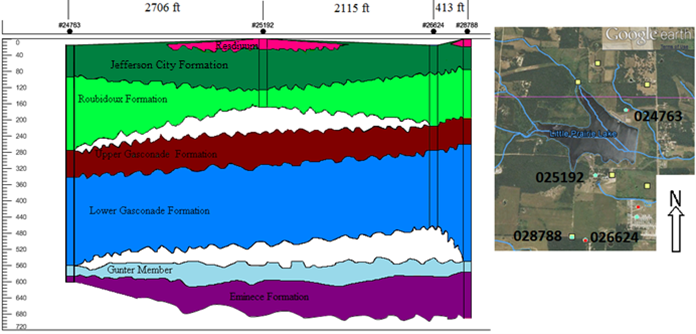
Figure D: Rock formations and surfaces in the area
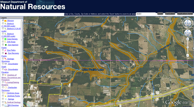
Figure E showing alluvium map of the study area
Before drilling down on the soil composition of the lake itself, it is perhaps useful to zoom out to a wider perspective. For the purpose of this part of the chapter, the wider area examined shall be the entire state of Missouri. Phelps County is roughly in the south-central part of the states, although it is a little west of center. The entire state of Missouri is broken into three major cross-sections. Most of the western and northern edges of the state are Pennsylvanian or cretaceous in nature. Most of the southern part of Missouri with the exception of the southwest corner and little spots and here and there along the border between the aforementioned Pennsylvanian/cretaceous line are Ordovician in nature. The rest of the state, the little dribs and drabs just mentioned, are in the southwest corner, along the northeastern edge and along the line between the two major portions of the state already mentioned. Simply stated, the state is cut in half mostly from east to west, and there are some isolated outliers of islands along the edges of the state and of each of the larger bodies. The one exception to this pattern is the extreme southeastern corner. That spot is tertiary/quaternary in nature (Missouri, 1978).
Some other tertiary details that should be noted before getting into the soil composition of the Little Prairie Lake also need to be examined. The annual precipitation in the area of the lake was about 40 inches in 1978. This was not far from the 42 inches that was the peak for the state, and that area was just to the west of the lake in question. Mean lake evaporation at that same time was about 40 inches in the area of the lake. The evaporation is higher in the west than the east. Rainfall surplus versus shortfall breaks even right around at the lake area. The lines for each two inches cut mostly from north to south and the lake itself has a surplus of two to four inches. The “zero” lines is about a third of the state to the west. However, going only to the east edge (a much shorter trip) leads to reaching an 8+ inch surplus (Missouri, 1978).
Regarding the soil composition, it consists of a series of blocks of different soil types with the root point of analysis in this instance being glacial deposits. For the most part, the state is sliced in half from east to west and the cut off line is basically where Interstate 70 exists right now. In terms of the aforementioned glacial deposits, the northern half of the state has less than one hundred feet of glacial deposits that are comprised of clay, silt, sand, gravel, and other particulates. The southern half of the state, excluding two small pockets but it does include all of Phelps County and the Little Prairie Lake, is comprised of chert/clay residuum and colluvium that is derived mostly from shale and clays. The lake area is sandy in areas underpinned by sandstone. This sandstone is between zero and thirty-five feet thick (Missouri, 1978).
When it comes to the soil beneath Little Prairie Lake in particular, there are a few facts that can be discussed. The composition is typical for the Salem Plateau Uplands. The lake itself as well as the associated watershed is underlain by Ordovician-aged Jefferson City dolomite. Some of the aforementioned Pennsylvanian deposits are also present in the area. There are medium to extensive pockets of dolomite that are actually watertight in nature. The above-mentioned material is overlaid by silt loam throughout the flood plain. The silt itself often has silt-laden clay underneath it, but above the rock bases mentioned above (Missouri, 1978). To drill down a bit on the Jefferson City Dolomite, there are more details that need to be noted. Dolomite is often also referred to as dolostone. It is from the geologic ages of Phanerozoic, Paleozoic, Ordovician-early/Ibexian. Dolomite is the primary rock type, sandstone is the secondary rock type, and other rocks that can be found here include shale, conglomerate stone, and chert. Jefferson City dolomite typically has a max depth of 350 feet (USGS, 2015).
The area in question is pretty indistinguishable from the area known as the Cotter Formation, which extends into parts of Arkansas. The Jefferson formation is found throughout the Ozark Plateau areas of Missouri. The Ozark Plateau is the largest area of land in Missouri, and it has several rivers, springs, and lakes. The dolostone is light- to dark-tan in color. It is fine in terms of grain and it is also crystalline. There are considerable amounts of chert along within beds of the aforementioned sandstone, shale, and oolite. Fossils are rare to none in the Jefferson formations. The totality of the Jefferson City dolomite itself sits on top of what is known as the Roubideaux Formation. The Jefferson City term to describe the dolomite type originates from the fact that it was discovered around Jefferson City in Cole County, Missouri. The just-mentioned Cotter Formation also extends in the Ozark Plateau area but is mostly relegated to southern Missouri. The facts above were discovered and entered into the record in the very late 1800’s. To be specific, the first credit is attributed to A. Winslow in 1894. It was entered as part of the Missouri Geological Survey in that year.
When it comes to water management areas like the Little Prairie Lake, the Towell Dam and the soil underneath, it is important to note some characteristics. When it comes to dammed areas, there are several factors to consider, as pond reservoir areas, drainage, irrigation, terraces, diversions and grassed waterways. Of course, the area in question has a mix of forested areas right by the lake, as well as some prairie areas, mostly on the southwest corner on the latter. The loam in the area of the lake comes in many forms, but there are about a dozen or two main classifications. They include Haymond silt loam, Lowassie silt loam, Glensted silt loam, Celt silt loam, Plato silt loam, Union silt loam, Rosati silt loam, Lebanon silt loam, Racoon-Freeburg complex, Deible silt loam, Horsecreek silt loam, Possumtrot fine sandy loam, Kaintuck fine sandy loam and Razort silt loam. In most cases, the slopes of these loams range from one to three percent. The minimum range is between zero and one percent, while the maximum is between two and five percent (USDA, 2015).
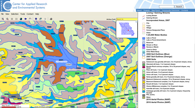
Figure F: Soil Map of Cares
One of the most important factors of the lake’s water management structure is how the soil, clay and so forth shift and shape the area is the freezing point in terms of temperature. When it comes to freezes, one can use twenty-four degrees Fahrenheit as a reference point. The freezes are usually finished by April 25th if using that dateas a yardstick because only once in ten years would freezing occur that late in the year. If one were to bump back to two out of ten, the date of the last freeze would be April 20th. For freezes reaching past a certain point half the time, that would be April 10th. When speaking about early freezes at the start of the fall and winter months, those dates would be October 16th (one in ten years), October 20th (two in ten years) and October 28th (five out of ten years). The growing season in the Phelps County area ranges from 186 days a year to 219 days a year, depending on when the start/stop points occur. The 186 day figure is valid for nine years out of ten and for one year out of tenthe growing season that lasts 219 days. This all reflects a minimum temperature of 32 degrees Fahrenheit (USDA, 2015).
Phelps County Sinkholes
There is a very large sinkhole that was discovered in Phelps County, Missouri. It has come to be known as the Conical Sink. The sinkhole is one hundred feet deep, and is directly adjacent to a county road. Upon its initial discovery, the sinkhole was literally used as a dumping ground and waste landfill continued until as recently as 2008. The sinkhole was later cleaned up, using a seventy-ton crane with a 202-foot boom at a cost of $9,150. Cleaning up the sinkhole took three whole days. There is another sinkhole, the Slaughter Sink, which is pictured in the fourth appendix while the Conical is pictured in the third. Further, there is an area known as the Dixon, Missouri Quadrangle. That area is interesting in that the aforementioned Slaughter and Conical sinks as well as Onyx Cave and Boiling Springs are all quite close together within the greater Dixon Quadrangle area (RollaNet, 2015).
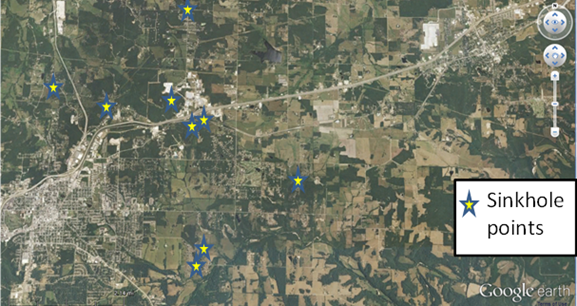
Figure G: Sinkholes Points
Sinkholes are common in Phelps County and are more numerous in the south and southeastern portions of the county where Roubidoux formation is deeply weathered. Sinkholes are an indication that the underlying bedrock is weathered, and contains enlarged joints and caves. Surface water enters the sinkholes, which percolate downward through opening in the soil and bedrock and eventually recharge the ground water aquifer. Ground water that supplies that many wells and springs in the county can be affected by contaminants, such as trash or garbage that are dumped into sinkholes.
As sinkholes are direct channels for the bedrock and underground, the protection of them is extremely important. Sometimes, the throat of sinkholes become filled with sediment, and when the soil breaks through, a bowl-shaped depression is created in the landscape. Sinkhole collapses can cause severe environmental and material damage.
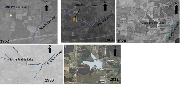
Figure H: Impact of Sinkholes over time
References
Arkansas. (2015, March 3). Ozark Plateaus: Ordovician. Retrieved March 3, 2015, from http://www.geology.ar.gov/geology/ozark_ordovician.htm
FindLakes. (2015, March 3). William E. Towell Dam, southcentral Missouri. Retrieved March 3, 2015, from http://findlakes.com/william_e._towell_dam_missouri~mo30090.htm
Missouri. (1976, January 1). Water Quality Characteristcs of Six Small Lakes In Missouri. Retrieved March 3, 2015, from https://www.dnr.mo.gov/pubs/WR33.pdf
MissouriCaves. (2015, March 3). Conical Sink Clean Up – Missouri Caves and Karst Conservancy. Retrieved March 3, 2015, from http://www.mocavesandkarst.org/conical-sink-clean-up/
RollaNet. (2015, March 3).
Caves and Karst In And Around Rolla. Retrieved March 3, 2015, from http://www.rollanet.org/~conorw/cwome/article2.htmUSDA. (2015, March 3).
Soil Survey of Phelps County, Missouri. Retrieved March 3, 2015, from http://www.nrcs.usda.gov/Internet/FSE_MANUSCRIPTS/missouri /MO161/0/Phelps_MO.pdf
USGS. (2015, March 3). Smithville Dolomite, Powell Dolomite, Cotter Dolomite, Jefferson City Dolomite. Retrieved March 3, 2015, from http://mrdata.usgs.gov/geology/state/sgmc-unit.php?unit=MOOjc

Time is precious
don’t waste it!

Plagiarism-free
guarantee

Privacy
guarantee

Secure
checkout

Money back
guarantee


