Modern Theories of Rent and Urban Economics, Term Paper Example
Introduction
In the UK, indices associated with the house prices have been the most closely matched economic indicators. This factor has been present since early 2014 because of the stronger than expected growth in housing demand as well as house pricing. As noted by Davies (2012, p. 56), this growth has taken place against the background of the recent significant government natives, which have been created with an aim of stimulating the UK house market, most significantly the introduction of the “Help to Buy” policy that was primarily designed to help people to give small down payments to purchase a home. With respect to the modern theories of rent and urban economics Bid rent theory (mono-centric and polycentric) (prime rents/ distance travelled) and the Central Place Theory (floor space/rateable value), cluster, this paper will rely on Colliers UK Office Rent Map plus Central London data to provide an analysis as well as an explanation of the patterns in office rents in the UK.
Modern Theories of Rent and Urban Economics
There is the need to gain an understanding of how the real estate market operates, to give readers an understanding of the relevant techniques and tools used in urban economics. While examining the non-residential and residential real estate market, from both micro-economics and mini-economics, and government’s role in the real estate markets, this section provides a discussion on the modern theories of rent as well as urban economics: Bid rent theory and the
Bid Rent Theory
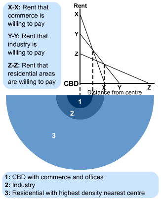
Primarily attributed to Edel (2013, p. 56), the Bid Rent Theory models the relationship that exist between house prices and distance from the city. The assumption made in this theory confirms that rents are bid upwards across the city center as households try to minimize the costs of transportation. With respect to this view, residents who live closer to the city centers have to travel less to get to entertainment spot of work environment (Edel 2013, p. 56),. On the other hand, rents are lower away from city centers since transportation costs for the residents are usually high. As a result of this factor, through the competition of minimizing the costs associated with transport, rents have become a negative function of distance from the city as illustrated in Fig. Besides, As shown in the Fig. 2, various land-users are not only prepared, but they also have the ability to pay for good access to the CBD.

Fig. 1: An illustration of the difference of how the distance from the city determines the rents of a specific area.
As shown in the simple model, rents are usually high near city centers and low in the periphery. With respect to this view, by living far away from the city center, residents always suffer high costs of transportation. In the gradient framework, the cost of transport is considered to be the opportunity cost of comminuting. This theory asserts that the time stent on commuting could be spent on things such as leisure or work, thus creating utility for the commuter. As a geographical economic theory, the bid rent theory revolves around how the demand as well as prices for real estate changes as the distance from the city center increases. Besides, the theory confirms that different land users will compete with each other of a land that is closer to the Central Business District (CBD). The notion that different land users will compete with each other of a land that is closer to city is primarily based upon retail establishments that wish to maximize profitability, hence they are always willing to pay more for a land that is closer to the city center and less for land that is far away from the city center. The bid rent theory, therefore , is based upon the reasoning that the more an area is accessible and closer to the city center, the more profitable it is.
As depicted in the diagram, it is evident that commerce is willing to pay the greatest rents to be situated in the central business district. The CBD serves as a very valuable for business and it has been traditionally the most accessible when compared to the large population. The larger population is considered to be a very essential element for department stores, which are in constant need of a considerable turnover (Mulligan, Partridge, and Carruthers 2012, p. 409). As a result of the increased turnover present in the CBD, commerce is constantly willing to pay declines rapidly. As one moves away from the CBD, on the other hand, industry is willing to be on the outskirts of the CBD as more land is available for the factories, but still have significant benefits of the central business, such as good communications and marketplace (Richardson 2013, p. 6). As one move further out of the CBD, the land becomes less attractive to the industry and the householders have the ability to purchase land in these areas. Essentially, the further one goes away from the CBD, the cheaper the cost of land becomes (Mulligan, Partridge, and Carruthers 2012, p. 407). As a result of this factor, inner city tends to become densely populated and characterized by high areas, flats and terraces. On the other hand, rural areas and suburbs are sparsely populated and characterized by semi and detached houses with gardens.
The Central Place Theory
In the Central Place Theory (CPT), the theorist attempts to provide an explanation to the size, number, as well as the spatial arrangements of a given settlement. Through the examination as finding the definition of the functions of settlement structure as well as size of the hinterland, the theorist established that it was possible to model the patterns of sentiment location with the help of geometric shapes. Originally published by Walter Christaller, the theory holds the assumptions that all areas have an evenly distributed population, evenly distributed resources, and have an isotropic (all flat) surface, similar purchasing power of all consumers and consumers will tend to patronize areas that are the nearest market, no excess profits (Perfect competition) and that transportation costs equal in all directions and proportional to distance (Mulligan, Partridge, and Carruthers 2012, p. 405). With respect to the description of the central place theory, it is worth noting that the theory seeks to find an explanation to the location, size and number of human settlement in an urban system.
Essentially, the central place theory focuses on the even distribution of population, all with equal opportunities and money, and the land is featureless and flat, and then settlements will follow a distribution pattern according to size. According to this theory, the distribution will follow one of three patterns:
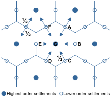
Market Optimizing
In market optimizing pattern, the shoppers in smaller settlements are divide into three equal groups whenever they shop in the three nearest larger settlements.

Fig 2. An Illustration of Market Optimization
Transport Optimizing:
In this pattern, shoppers in smaller settlements tend to divide into two equal groups when they shop in the two nearest larger settlements.

Fig. 3 An Illustration of Transport Optimization
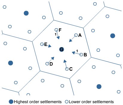
Administration Optimizing:
In this pattern, all shoppers in smaller settlements will shop in the nearest large settlement.

Fig. 4 An illustration of Administration Optimization
As evident in the diagram, the largest settlement, which appears at the center of the diagram, will be surrounded by a number of smaller settlements. As a result of this factor people coming from small settlements will visit the large settlement for specific service or good or service that they may not be providing. With respect to this view, people may not have the access of boundary hexagons since they may resort to shopping to a place that is central to them.
Changing Tenure Patterns in UK Major Cities
The City of London
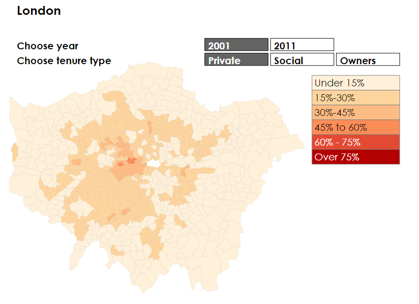
One of the greatest trends in the housing in the UK, over the last few decades has been the ever-increasing number of people who live in the private rented sector. By the year 2011, there were more people in the private rented housing when compared to those in the social rented housing. On the other hand, the number has doubled over the past decade. While putting into consideration of how the recent changes in patterns of office rents have played out geographically Mulligan, Partridge, and Carruthers (2012, p. 405) used the UK census data from 2001 and 2011 and examined the changes that have taken place in the Manchester Glasgow and London. With respect to the importance of understanding the recent trends, the authors used the Colliers UK Office Rent Map plus Central London data. For both 2001 and 2011, one looks at the proportion of people living in each ward in the social rented, private tented as well as the owner occupied housing (Mulligan, Partridge, and Carruthers 2012, p. 405). As shown in Fig 5, the higher the proportion of people who live in an area, the darker the color, light orange symbolizes fewer than 15 percent of the population, deep red represents 71 percent.

Fig 5. A representation of Patterns of Office Rents in London between 2001 and 2011
There are a number of things that emerge in the diagram. To begin with, the privately rented offices in the city have continued to go up, moving from being largely the Inner London tenure to take up at lease a sixth of the most outer London as well. It is very interesting to confirm that the areas that are characterized by the lowest levels of private rentals in the outer east and the outer south tend to be a bit higher. With respect to this view, it is worth noting that social renting has continued to decrease over the years. However, as depicted in the diagrams, the changes in the owner occupancy are quite substantial. While owner occupancy have become more substantial, what was previously considered to be a pretty solid ring of dark red in areas around London have become orange patches. Whereas Havering and Brimley has become significantly owner occupied, the differences that exist between tenures in the outer and inner London are increasingly closing. The city of London is massive as its population stands at 8 million. It is made of 32 municipalities and it has become common for people to live in one municipality and work in another, or even move between these municipalities (Mulligan, Partridge, and Carruthers 2012, p. 405). Besides, as established therein, there is a significant difference between the center of the city of London that has social and private accommodation and the suburbs, which are characterized by owner occupation.
Manchester City
When Fig 6 is closely observed, there is some significant difference. As shown in the diagram, the share of owner occupancy is seen to be higher in Manchester that it is in London. Besides, whereas the private rented offices have continued to spread, there are very few places where it makes up a third of the stock.
The similarities that exist between Manchester and London are not only possible, they are also interesting. As shown in the fig, there are more people occupying the private rented sectors, fewer social renters and fewer occupiers (McCann 2013, p. 56). Besides, the outer ring of the greater Manchester is characterized by a high proportion of occupiers when compared to the inner circle. Whereas that core could be much smaller in the city of London, the fall in owner occupancy in the outer areas could mean a significant difference between the core and the suburb is closing.
Glasgow City
Comparing between London and Manchester, it is worth noting that Glasgow is quite different. To begin with, some of Glasgow’s suburbs are significantly sparsely populated, meaning that the constituents can take up large areas. As shown in the above fig, there are huge constituents that are sparsely populated meaning that they take up large areas (Parker 2015, p. 56). While there are huge constituents towards the south of the map, they tend to distort the picture by being one solid color. Besides, there is very little rented office accommodation in Glasgow, when compared to other cities that have been examined (Papageorgiou and Pines 2012, p. 65). There are only two constituents in the whole of the larger part of Glasgow, where over 30 percent of the population is in the private rented sector. Besides, there is not big fall in the owner occupancy. While some areas in the North West have seen the falls, there have been significant increases elsewhere. Similarly, the decrease of social renting between the suburbs and the core remain strong.
Discussion of Key Issues
As far as the Land Rent and Rent Curve is concerned, it is worth noting that there are three concepts are at the core of the land rent theory. The core concepts include rent, rent gradient, and the bid rent curve function. Rent is defined as the surplus (profit) that results from some advantage such as accessibility as well as capitalization. Rent is based on an individual’s capability to pay and it is usually the highest for retail since this activity is dependent on the accessibility to generate income (McCann 2013, p. 56). Gradient, on the other hand is referred to as the representation of decline in rent with distance from the point of reference, which is always at the city center. Gradient has a close relationship with the marginal cost of distance for each activity that is a representation of distance influences the bidding rent. With respect to this view, it is worth noting that the friction of distance is of great significance and greatly impact the rent gradient since with no friction all locations there would be perfect locations. Lastly, bid rent curve function: this refers to the set of land price combinations as well as the distances among which a firm of an individual is indifferent. The bid rent carve provides a description on the prices that the household (firm) may be willing to pay at different locations with an aim of achieving a given level of satisfaction, in form of profits and utility. Besides, it concerns the activity having the highest bid rent at a given point is theoretically that will occupy a specific location.
For instance the above figures are an illustration of the basic principle of the land their, which assume that CBD presents the most desirable location of high accessibility levels. Areas within a radius of 1km have a 3.14 square. Under these kinds of circumstances, the rent serves as a function of the availability of rent, which is basically expressed as 1/S (Edel 2013, p. 58). At zero distance, rent is at the highest point and as one move away from the center of city, the rent drops significantly because the amount of the available land will increase exponentially. There is more land that is available to bid on; therefore, if the supply goes up the prices will go down. It is worth noting that rent/distance relationship has a significant relationship on the use of land.
Urban theories that have been examined in this paper have been used to identify the key factors that can be used in determining the spatial patterns that are associated with the value of land as well as in rental values both at the national levels as well as the individual level of the city (Edel 2013, p. 56). The results that have been obtained from the analysis with regards the factions of a population offers significant support that argues that in general, the high and larger cities have the ability to sustain the value of rents. Besides, both the bid rent theory and the central place theory have provided significant explanation to the spatial distribution of London, Manchester and Glasgow. Through understanding rent as a function of the size of the city and the fact that cities are not positioned in a random way, the trend in the three cities have provided a clear explanations as to why office rents have a significant variations across the UK. When conducting an examination on rent as a function of distance away from the dominant city center is a clear negative relationship. Basically as the distance from the CBD increases, the value of rents decreases. This has been clearly explained in the theories highlighted in this paper that as the demand of space continues to increase in the CBD, it tends to reduce the cost of transport and increase profitability.
Conclusion
In relation to the rent and urban economics theories, such as the Bid rent theory (mono-centric and polycentric) (prime rents/ distance travelled) and the Central Place Theory (floor space/rateable value), cluster, this paper has relied upon the Colliers UK Office Rent Map plus Central London data to provide an analysis as well as an explanation of the patterns in office rents in the UK. In the essay, the central place theory holds the assumptions that all areas have an evenly distributed population, evenly distributed resources, and have an isotropic (all flat) surface, similar purchasing power of all consumers and consumers will tend to patronize areas that are the nearest market, no excess profits (Perfect competition) and that transportation costs equal in all directions and proportional to distance. On the other hand, the assumption made in this theory confirms that rents are bid upwards across the city center as households try to minimize the costs of transportation. With respect to this view, residents who live closer to the city centers have to travel less to get to entertainment spot of work environment (Edel 2013, p. 56). On the other hand, rents are lower away from city centers since transportation costs for the residents are usually high. With respect to the highlighted theories, it is evident that indeed the current patterns in office rents are a true reflection of the concepts outlined in this paper. There is a need for extensive research that will provide further understanding of the concepts in relation to the distribution of offices in urban centers.
Reference List
Davies, R., 2012. Marketing Geography (RLE Retailing and Distribution): With special reference to retailing. Routledge.
Edel, M., 2013. Urban and regional economics: marxist perspectives. Taylor & Francis.
McCann, P., 2013. Modern urban and regional economics. Oxford University Press.
McCann, P., 2013. Modern urban and regional economics. Oxford University Press.
Mulligan, G.F., Partridge, M.D. and Carruthers, J.I., 2012. Central place theory and its reemergence in regional science. The Annals of Regional Science, 48(2), pp.405-431.
Papageorgiou, Y.Y. and Pines, D., 2012. An essay on urban economic theory(Vol. 1). Springer Science & Business Media.
Parker, S., 2015. Urban theory and the urban experience: Encountering the city. Routledge.
Ponsard, C., 2012. History of spatial economic theory. Springer Science & Business Media.
Richardson, H.W., 2013. The new urban economics: and alternatives. Routledge.

Time is precious
don’t waste it!

Plagiarism-free
guarantee

Privacy
guarantee

Secure
checkout

Money back
guarantee


