Stability of Rock Slopes, Research Paper Example
Abstract
This project will incorporate geotechnical and geological facets of risks and hazards related to rock slope failures. Traditionally, rock slope stability analyses are performed to determine the economic design of manmade or natural slopes. These slopes often include open-pit mining, embankments, road cuts, landfills, and excavations. The primary objective of slope stability analysis is to identify potential failure mechanisms and endangered areas. It is also used to determine slope sensitivity for various triggering mechanisms so that new slopes can be designed to express optimal safety, economics, and reliability. This is typically done as a post-analyses procedure and refers to slope stabilization through the implementation of barriers and so forth. Successful slope design depends on site characteristics and geological information such as slope geometry; rock mass, groundwater conditions, joint systems, materials alternation by faulting, and earthquake activity.
The analysis of earth structure stability is one of the oldest numerical analysis in geotechnical engineering. More specifically, the limit equilibrium method is utilized to assess the stability of earth structures. Limit equilibrium methods are used most effectively when inherent limitations are fully understood.
The project examines the risk as it relates to large rock-slope failures. Rock avalanches are perhaps one of the most serious global natural disasters. Many people lose their lives annually as the result of rock avalanches and related tsunamis.
Introduction
The successful design of a rock slope is determined by site characteristics such as slope geometry, groundwater conditions, rock or soil mass, earthquake activity, and movements and tension in joints (Abramson, Lee and Sharma). Similarly, the choice of correct analysis method depends on the potential mode of failure, as well as the site conditions. Prior to the availability of computers and related computer-generated programs, analyses were performed through the use of handheld calculators. Today, analyses are performed through software programs that range from simple limit equilibrium techniques to more complex limit analysis approaches. Successful analyses depend on the engineer’s understanding of the limitations of each technique. In addition, risk assessment is a more commonly used concept in slope analysis and refers to the consequences of slope failures as well as the probability of such failures (Bishop and Morgenstern). It is important to note that neither the consequences of slope failure, nor the probability of slope failure can be assessed without an accurate understanding of the failure mechanism.
First Project Overview
Addressed Themes for Møre & Romsdal County in western Norway
- Means to quantify rockslide hazards
- Progress of geological models for rock slopes
- Stability analysis, which includes probabilistic analysis and sensitivity analysis
- Distortion and monitoring processes
- Micro-seismic observations
- Rockslide dynamics and pragmatic modeling
Project Foundation
Means to Quantify Rockslide Hazard
This project utilized existing data from More & Romsdal to evaluate means for hazard assessments in regional and local areas that pose as a risk in Sweden. A hazard zoning was performed based on longitudinal distribution and sequential pattern of events. In addition, the assessments were based on the age, prevalence, and size of each event in a specific area. The potential for tsunamis were also taken into account during this project’s risk assessment (Christian, Ladd and Baecher).
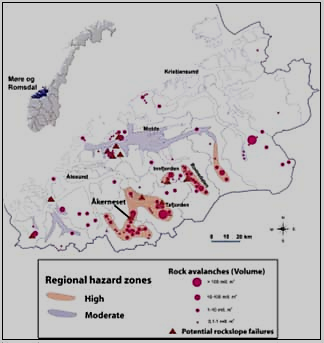
Figure 1: Rock avalanche events and regional hazard zones in the Møre & Romsdal county, western Norway.
Figure 1 is a shaded relief model which illustrates strip bathymetry data from Sunnylvsfjorden in Møre & Romsdal county, Sweden to indicate large rock-avalanche deposits. The data presented in this illustration, combined with reflection seismics are used to evaluate the particular level. Hazard levels are measured by the frequency, distribution, and magnitude of events. The numbers indicate the volume of separate events and are measured in million m3 (Christian, Ladd and Baecher).
Progress of Geological Models for Rock Slopes
The geological dataset is the most reliable means to determine rock-slope failure assessments. As such, it is crucial to implement realistic models that are based on a comprehensive understanding of structures. These models depend on three-dimensional kinematics and friction-related stability (fault rock membranes and fractures). With that in mind, the following models are used:
- Digital elevation models (DEM): This is used to identify the importance of structural patterns that indicate instability features; for example sliding planes and wedges. This is best achieved through the use of a ground laser scan or airborne light detection and ranging. DEM is also used to identify a rock slope’s limits of instability and main sets of discontinuities and their subsequent orientations (Malkawi, Hassan and Sarma). These methods have been tested in Oterøya and Åknes in Norway and have proven successful. As such, DEM was used for this project to aid in the acquisition of ground-based laser scan data of rock slopes, and in the development of methods for initial assessments.
- 3D geometry of rock-slope failures: This model focuses on detailed slope-failure investigations so that engineers can identify the diagnostic structures for such features. Through the use of geophysical methods, such as two-dimensional resistivity and seismics, mapping can be done to identify deeper structures. If possible, drilling should be used for this method as well.
- Geo-mechanical uncertainties in rock slope stability assessment: Shear fracture characteristics are the most suitable foundation to determine rock-slope stability and to utilize risk assessments (Christian, Ladd and Baecher). Studies based on collapsing mountain sides indicate that the majority of rock-slope failure areas contain both tension fractures and shear. It is therefore crucial to link the shear-strength relationship for ungrouped water-saturated fault rock and sliding planes.
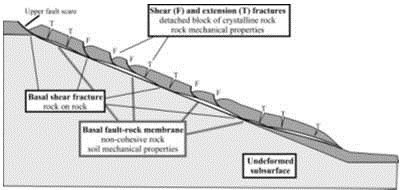
Figure 2: Two-layer model of rock-slope failures for pre-avalanche distortion. The text describes mechanical properties that must be evaluated during stability assessments.
Stability Analysis
(Includes Probabilistic Analysis and Sensitivity Analysis)
This method focuses on the stability analysis and modeling of the rock slope. Findings from this method will be combined with work from geological models. For this project, this method was used to perform modeling for a 700 meter high rock slope in western Norway. Both a stability and dynamic rock slope analysis were performed (Abramson, Lee and Sharma). Geotechnical field data was analyzed to assess the applicable statistical distributions. Also, this method performs probabilistic methods and numerical techniques separately. Through a combination of both approaches, the results will complement one another to better explain the rock-slope failure phenomenon.
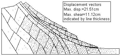
Figure 3: This is a representation of displacement vectors and shear displacements of a jointed rock slope post preliminary fixed loading. Shear displacements are indicated by the thick line.
Distortion and Monitoring Processes
Three-dimensional kinematics indicates the movement patterns of rock slopes. A comprehensive understanding of this kinematics is crucial for a proper evaluation of hazards, as well as numerical modeling.
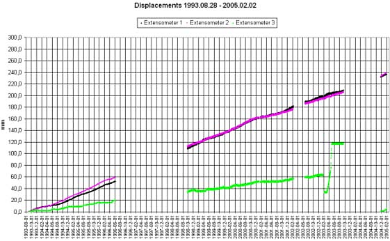
Figure 4: This graph indicates movements as measured by the extensometers at the Åknes failure in western Norway.
Micro-Seismic Observations
This monitoring method was first employed at the Aknes failure. It is a passive micro-seismic monitoring method that can identify micro-seismic events. In other words, it can identify unstable rock slope sites and identify events that relate directly to the mass movement of the rock slope (Malkawi, Hassan and Sarma). This collective information will provide significant information on the internal structure and active behavior of the respective slopes. For this specific slope, the researchers observed nearly 400 seismic events after monitoring the site for 71 consecutive days. Through the use of intensive geophones, the researchers discovered an estimated 3.5 micro-seismic events each day. Although they could not accurately localize the seismic events, they were able determine the direction of the strongest incoming signals. These signals were generated within the slope, indicating that rock slope failures are often the result of an internal disturbance (Lam and Fredlund).
Rockslide Dynamics and Pragmatic Modeling
In Norway, specifically, an abundance of rock avalanches have been reported. Some of them exceeded 100 million m3 in volume. In order to conduct accurate tsunami modeling and to understand its run-out potential, it is crucial to understand the slide dynamic and secondary processes that relate to slide impact (Bishop and Morgenstern). The rockslides used for this project are excellent examples that can be used to develop statistical models that will indicate run-out potential.
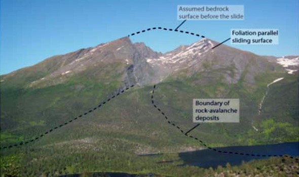
Figure 5: Shows the slide scars and large rock deposits of a rock avalanche in Balsfjord, Troms, Norway. This picture indicates that the failure occurred along the foliation planes.
Rock Slope Failures
Early developers of rock slope failures recognized inherent barriers to accurately determine realistic stress distributions. For instance, researchers in 1969 noted that normal stress at a certain point is primarily influenced by the weight of the soil directly above that point. As such, other factors could easily influence the base normal stress. Through the years certain advancements have been made and now concentrated loads are incorporated into the methods to stimulate the equipment. However, if concentrated loads points can be unified in the method, then lateral concentrated point loads can be used to represent reinforcement (Bishop and Morgenstern). This has now become the common practice in limit equilibrium stability analyses.
This method, however, has various side effects. For instance, stress distributions may be wholly unrealistic as the critical slip surface may be in an unrealistic position. For that reason, results may be difficult to interpret.
Seismic and Dynamic Forces
Both seismic and dynamic forces are typically multi-directional, oscillatory, and are active only for short periods of time. Yet, despite its complex characteristics, static forces sometimes represent the effect of dynamic loading. Also, although the slope may not fully collapse during a shake, it may result in permanent deformation. The best way to consider dynamic effects is through a pseudo-static analysis.
Sometimes dynamic loading happens so quickly that the soil strength behaves in an un-drained manner. This is especially true for clay-like soils, but not for rock fill or unsaturated gravels. A limit equilibrium formulation therefore identifies those forces that act on a slice, so that the slice is in force equilibrium. This means that the safety factor is identical for each slice. Therefore, if a dynamic force is applied to a slice, slice forces will readjust. This entails a readjustment of the base shear strength.
First Project Conclusion
Engineers perform slope stability analyses to determine the economic and safe design of natural and man-made slopes. These slopes range from open-pit mining to landfills and embankments. Slope stability generally refers to the resistance of an inclined surface to fail in structural integrity by collapsing or sliding. The purpose of a slope stability analysis, therefore, is to find the endangered areas that are most prone to failure or collapse. It also investigates potential failure mechanisms and determines the slope sensitivity to varying mechanisms that can contribute to its failure. Once all this information is collected, safety precautions, reliability measures, and economic interventions to aid in slope stabilization can be implemented.
Successful slope design depends on geological information and crucial site characteristics such as the mass of the soil or rock, the slope geometry, tension joint movements, groundwater conditions, and earthquake activity. The appropriate analysis technique is based on the site conditions of the slope, as well as the various probabilities of failure. In other words, through a comparison of the various analysis methods, such as comparing its limitations, strengths, and weaknesses, the engineer will determine the best possible method. Engineers today use various computer-generated methods to assess the rock slope stability and risks. The concept of risk assessment is becoming increasingly more popular today and refers to the probability of failure, based on the aforementioned conditions, as well as to the consequences of such a failure. Slope stability radar is commonly used to scan a rock slope to identify its internal structure and probable failure.
Second Project Overview
Addressed Themes for Little Nelchina River in Alaska
- Physical Setting
- Site Description
- Stability Analysis
Physical Setting
Between July 1972 and October 1973 the Alaska Department of Transportation and Public Facilities (AKDOTPF) constructed a highway alignment over the valley of the Nelchina River. The purpose of the project was to straighten an oil line approximately 700 feet south of the highway alignment (Barton, Lien and Lunde). However, after the construction a high cut slope and waste area were observed. Also, approximately two years after the initial alignment, movement was observed between two stations. In an effort to identify the cause of movement, the AKDOTPF initiated a field exploratory drilling program. Unfortunately the program was unsuccessful due to continuous slope embankment movements (Barton, Lien and Lunde). Two alternate solutions were recommended to maintain the road: 1) install reinforced concrete piles at the site, or 2) replace the head of the slope with rock buttress. Figure 6 below shows the exact location of the site.
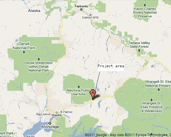
Figure 6
Site Description
Located east from the Little Nelchina River, the highway crosses a low sedimentary terrace. Drainage happens to the right of the terrain, which is generally level; however, there are various narrow, but deep, gullies across the actual highway. The general location of the project is located on the Copper River Basin with an elevation that ranges between 500 to 4,000 feet. Groundwater was present at the base of the fill of the existing clay stone at the site. In addition, vegetation mostly consists of heavy moss and dense white spruce. The Nelchina River flood bank consists mostly of sand and gravel and the two most prominent soils are clay stone deposits (Bieniawski).
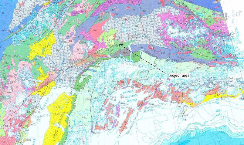
Figure 7 Site Geology Map
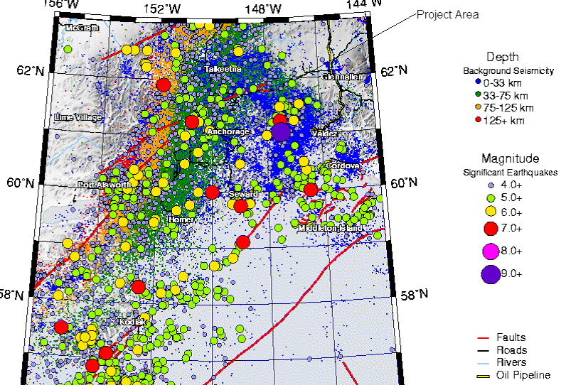
Figure 8 Seismicity of Project Area
Figure 4 indicates a moderate seismicity at the project location. According to the Alaska Earthquake Information Center an average earthquake has a magnitude of 4. As such, the seismicity information for the project site will not have a significant impact on the project area. Through an economic design the engineers want to stabilize the east-embankment and cut slopes between stations 117 and 125, implement long-term stability for the actual highway, and provide a profile of the center of the area located at station 124. This profile will provide means to stabilize the slope through economic and effective measures (Bieniawski).
Stability Analysis
A comprehensive engineering design is required to stabilize the east embankment and cut slopes between stations 117 and 125. The cut slope between station 122 and 125 is 300 feet long. The design will therefore focus on a long-term stability design to provide the most appropriate remediation plane. The majority of the slide area consists primarily of clay stone, which is hardened clay. In addition, the clay soil was restricted by sedimentary rock, which means it is difficult to separate into thin layers. The water table consists primarily of stone layer. This means that the engineers will have to build a drainage system so the slope can be effectively stabilized. However, their endeavor will be met with the obstacle of clay stone, which does not easily permit water drainage.
Because no tests existed to measure current soil properties, the engineers will have to employ Geoslope, which is a computer program that can run various values of unit weight, friction angles, and cohesions in order to accurately determine values for soil materials. Figure 9 indicates the cure of proper material analyses.
| Materials | Unit Weight (pcf) | Cohesion (psf) | Friction Angle (°) |
| Till (soil #3) | 130 | 2,200 | 40 |
| Clay Stone (soil #2) | 115 | 200 | 10 |
| Sandy Gravel (soil #1) | 128 | 0 | 38 |
Figure 9 The input data for different material for different materials for F.S. = 1 at station 124
The most appropriate material properties at the point of failure depend on the safety factor, defined as 1.0. The analysis was returned until a factor of safety was equal to the unity. The conclusive data, presented in Figure 9, indicate that the most effective factor for soil is cohesion. As such, the engineers will analyze the range of cohesion for each type of soil to determine the most appropriate one so that the factor of safety will be equal to 1.0. Based on the aforementioned analyses, there are four possible methods that can be employed to stabilize the embankment:
- Because the water level is close to the ground surface high water pressure can and will develop in the deep ground. Also, because this project is located in Alaska the water will freeze during winter and thaw during the spring, thereby compromising slope stability. Drainage will therefore be a feasible means to stabilize the embankment;
- The embankment failure profile from station 120 indicates that the slide surface coincides with the boundary of the silty clay. As such, the clay stone is the primary reason for slope failure. Excavating the clay stone from the site will therefore stabilize the embankment;
- A soil nail can be installed into the clay stone (which is only the first layer of the soil, and is also relatively thin). Installing a soil nail at an angle could aid in the stability of the embankment;
- A buttress can be built at the bottom of the landslide, provided there is enough ground below the slide to sustain the buttress foundation. Buttresses are effective means to stabilize both circular and translational slides.
Conclusion
Based on the information collected for both projects, it is evident that various measures exist to effectively analyze the cause of rock slope failures, to determine the effects of rock slope failures, and prevent rock slope stability. Quantitative rock slope assessments are effective means of rock slope engineering in cases where there are various points of failure. Also, through quantitative rock slope assessments, engineers can accurately determine rock mass quality estimates of slopes. This is also an effective safety assessment method. In addition, this method will determine discriminant functions to evaluate a slope’s failure probability.
References
Abramson, L.W., et al. Slope Stability and Stabilization Methods. New York: John Wiley & Sons Inc, 2002.
Barton, N., R. Lien and J. Lunde. “Engineering classification of rock masses for the design of tunnel support.” Rock Mechanics 6.4 (1974): 189–236.
Bieniawski, Z.T. The geomechanics classification in rock engineering application. New York: Wiley, 1989.
Bishop, A.W. and N Morgenstern. “Stability coefficients for earth slopes.” Geotechnique 10.4 (1960): 164-169.
Christian, J.T., C.C. Ladd and G.B. Baecher. “Reliability Applied to Slope Stability Analysis.” Journal of Geotechnical Engineering 120.12 (1994): 2180-2207.
Lam, L. and D.G. Fredlund. “A general Limit Equilibrium Model for Three-Dimensional Slope Stability Analysis.” Canadian Geotechnical Journal 30 (1993): 905-919.
Malkawi, A.I.H., W.F. Hassan and S.K. Sarma. “Global Serach Method for Locating General Slip Surface Using Monte Carlo Technique.” Journal of Geotechnical and Geoenvironmental Engineering 127.8 (2001): 688-698.

Time is precious
don’t waste it!

Plagiarism-free
guarantee

Privacy
guarantee

Secure
checkout

Money back
guarantee


